

AccuWeather.com predicts active severe weather this summer for portions of the Great Lakes to the mid-Atlantic.
As the summer of 2012 warms us up, the La Niña pattern, or cooler-than-normal water temperatures over the central and eastern equatorial Pacific, that has been in place for the past two years is over.
This summer, the pattern is transitioning into an El Niño pattern, which is characterized by above-normal water temperatures in the central and eastern equatorial Pacific.
Hot spells will reach eastward into the Midwest at times during the summer. Chicago will have some heat surges, but rounds of wet weather and even severe weather will keep heat waves from lasting very long.
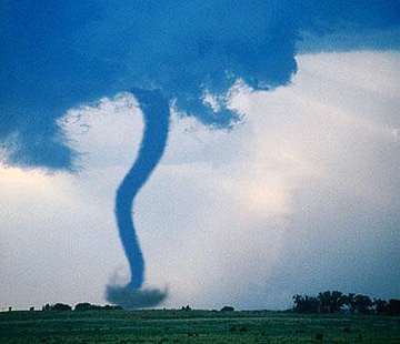
An active severe weather season will extend into the summer. Storms will ride over the northeastern edge of heat with increased chances for severe weather from the Great Lakes to portions of the mid-Atlantic. This type of severe weather pattern is often referred to as “ring of fire” storms.
Michigan and Minnesota to portions of Kentucky, Virginia, Maryland and New Jersey will lie in the battlegrounds of severe storms at times. Cincinnati, Ohio, Lexington, Ky., Washington, D.C., and Philadelphia are among the cities at risk for active severe weather.
During the early and middle part of the summer, the threats may include damaging winds and the threat for tornadoes before the northern jet stream weakens and an El Niño pattern sets in. Later in the summer, there may be a shift to more heavy rain events in the unsettled zone.
For more information, contact:
roberti@accuweather.com
Or AccuWeather.com. 24-hour press hotline: 814-235-8710


Be First to Comment